Ask Latest Price
Active Member
11 Years

DongGuan Sinowon Precision Instrument Co., Ltd. (2)
Sinowon Innovation Metrology Manufacture Limited Your Vision is our Mission

Add to Cart
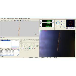
Vision Measuring System Software With Data Management Graphical Representation
1. Powerful Measuring Function:
It can measure multiple 2D functional elements directly such as point, line, circle, arc, rectangular, groove, ring, open curve, close curve, etc. And it can get a combination of split, vertical, intersection, tangent, parallel and other elements combinations ;
With NURBS curve fitting algorithm, it can measure perimeter, area, diameter of curve and make it closer to real data;
It can simply measure sphere, cylinder, cone, plane and other 3D functional elements by video points focus.
2. Multiple Measuring Mode:
Including automatic edge finder, automatic section finder, directly access to point by click mouse, cross point, nearby point, contrast, mining point, contour mining point, plucking point, probe point, laser point and so on.
3. Tolerance Setting
Support group tolerance, such as Circularity, Concentricity, Perpendicularity, Parallelism,etc. If the results is over the tolerance values, it will give an indication for PASS or Fail features.
4. Construction Function
Select two or more features to create intersections or constructions. This can offer user more multiple method to get measurement results.
5. Powerful Label Function
It offers several label modes such as distance, angle, X distance, Y distance, radius, diameter, arc and so on.
Label position can be corrected after label.
Available automatic label.
Label is still reserved after stop user program.
6. Map Navigation Function, Scan Function and Contour Tracing Function
This software equipped with powerful navigation function, is able to scan the whole map by specified the first point and the last point.
It can also import and scan the picture by external sensor.
Scan function can be used for reverse function, specify the first point and the last point, with special design calculate method, can filter dot, highly enhance the scanning applicability and accuracy.
Contour tracing function can contour trace the open or closed image and get the right contour.
It can set dot number for the contour and the software will calculate the scanning distance automatically.
